Pickett Applied Technologies Laboratories filed a U.S. provisional patent application for Twidget on 1 October 2026. Application 64/166,977 covers systems and methods for passive, multi-antenna, multi-unit radio-frequency sensing and cueing of emitting unmanned aircraft when a site is under emission control.
A provisional starts the priority clock. It is not an issued patent, and it is not examined. What follows is a plain-language look at the idea in that filing.
The problem the filing starts from
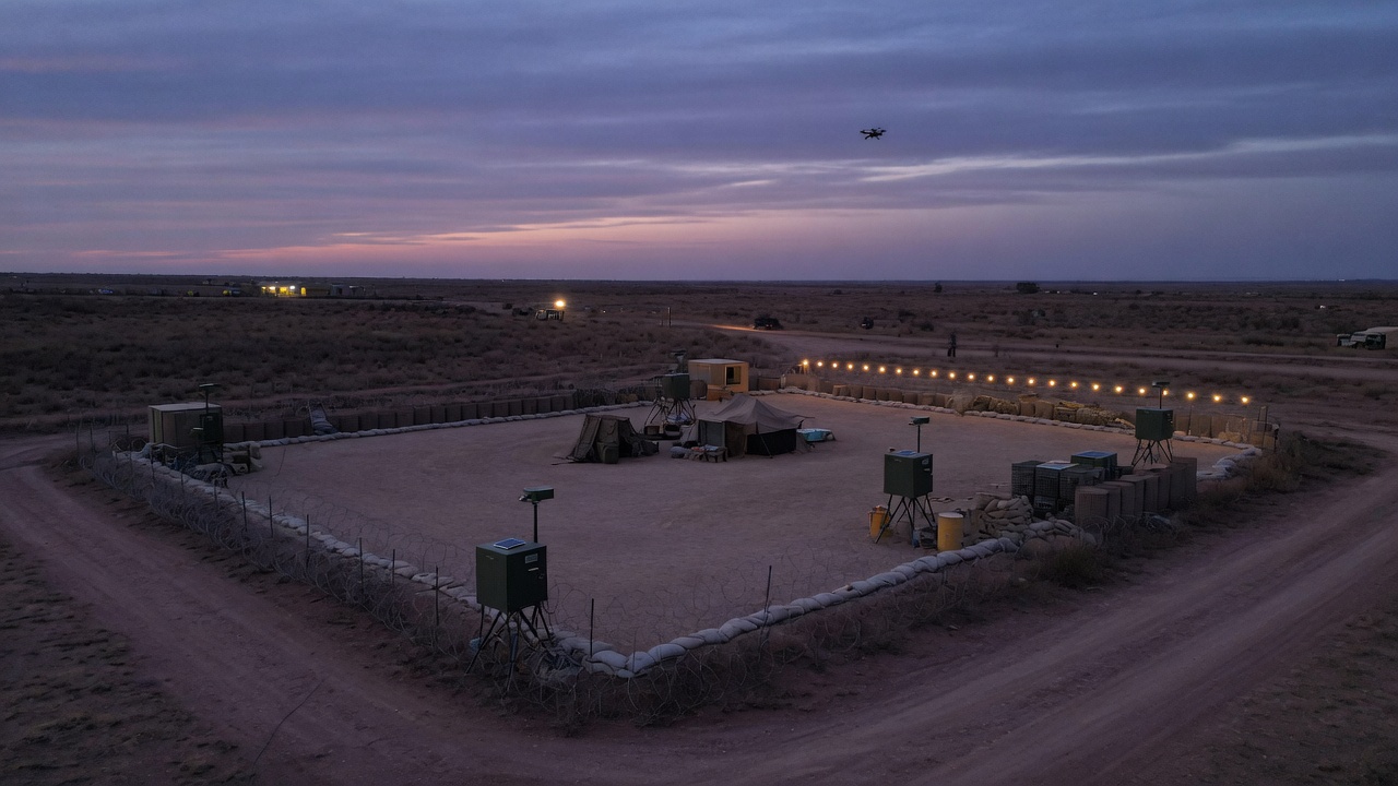
Bases and forward sites often have to stay quiet on the air. Active radar and jammers tell an adversary where you are. Many small aircraft do not stay quiet. Video links, control links, and the electronics and motors on the airframe radiate, sometimes only in bursts and only from certain aspects.
A single passive receiver struggles with that. Weak, intermittent energy looks a lot like noise, and one node raises too many false alarms. Twidget is written as a receive-only layer that checks a detection more than once before it hands a cue to the command system already on the site. Engagement stays with the effectors the operator already has. The sensor is not a weapon and it does notclose a kill chain by itself.
What a sensor unit is
Each unit listens. It does not transmit, interrogate, or radiate a local-oscillator beacon.
The preferred unit in the specification uses several wideband antennas and a low-noise receive chain on each one. Planar taperedslot antennas (the Vivaldi family) are the example, sized for a very wide instantaneous band, with attention on the links small aircraft actually use, including 2.4 GHz, 5.8 GHz, and higher.
The front end is built for a hard dynamic-range problem: a distant, low-power emitter and a strong nearby signal should not force the same gain setting. The filing describes cascaded low-noise amplifiers, a digital step attenuator with detector-based automatic gain control as the everyday control, and a wideband limiter as a backstop. An optional shared high-gain path can take a second look after a first coincidence, instead of running every channel at maximum gain all the time.
Coincidence is the point
Noise on one channel is a poor reason to wake an operator. A real emitter tends to show up together in time across antennas, and again across units that are not standing on the same patch of ground.
The method in the filing stacks those checks: Each channel compares what it hears with its own adaptive background. Inside one unit, several channels have to cross that background together. The preferred rule is three of four. Two of four and four of four are described as confidence tiers, not as a different product.
Across the site, separated units have to agree inside a short time window. The preferred rule is two of three, or two of four. Optional frequency-bin agreement, hysteresis, and a short energy integration step keep a flicker from becoming a track and keep a real track from dropping on one missed look. Machine learning, if it is used at all, comes after coincidence. It refines a detection. It is not the detector.
A provisional expires twelve months after filing unless a non-provisional application, a Patent Cooperation Treaty application, or both, is filed in time and claims its benefit. Informal drawings in the provisional can be replaced with formal line drawings at that step.
The hero images in this post are illustrations for the website. The two numbered figures are the informal drawings from the application as filed.
Twidget is a discreet, passive drone-detection concept from Twidget International and Pickett Applied Technologies Laboratories. This article describes a pending provisional application. It is not legal advice and it is not a performance specification
Every day, aircraft over the Baltic show up on screen hovering over the sea when they’re actually over land. Ships in the Eastern Mediterranean report fixes that put them at inland airports. Timing receivers see their clocks jump by hundreds of nanoseconds. This used to be an edge case. Now it’s a routine operating condition, and for communications and navigation teams the hard part usually isn’t knowing something is wrong. It’s working out what, where, and why quickly enough to act.
That’s why we built AEGIS Sentinel.
The problem is no longer occasional
The numbers tell the story:
In July 2026, EASA published the fourth revision of its safety bulletin on GNSS outages and alterations. It warns that incidents are becoming more severe, more sophisticated and more disruptive, with the Baltic Sea, Eastern Europe, the Mediterranean, the Black Sea and the Middle East among the most affected areas. (Geoawesome)
Finland’s transport agency Traficom received 1,704 reports of GPS interference in 2025, then 421 in just January and February 2026. (CNN)
Between mid-July and mid-August 2024, around 41,000 flights were spoofed. That’s about 1,500 per day, up from roughly 300 per day earlier that year. (OPSGROUP Spoofing Workgroup report)
Figures from IATA’s 2025 safety reporting show GPS jamming up 67% and spoofing up 193% between 2023 and 2025. (MigFlug, citing IATA)
Aviation isn’t the only victim. GNSS supplies the position and timing behind shipping, mobile networks, power grids and financial systems. And GNSS problems often arrive alongside other failures: cut submarine cables, satellite uplink faults, and HF blackouts caused by space weather.
The data about these events usually sits in different places: NOTAMs, operator reports, spectrum monitors and space-weather feeds. AEGIS Sentinel puts it all on one screen.
What AEGIS Sentinel does
AEGIS Sentinel is an interactive analytics dashboard built for communications and navigation experts. It runs as a single HTML file, so there’s nothing to install and no server to maintain. It opens in any modern browser on desktop, tablet or phone.
1. The situation at a glance
Six headline tiles show active incidents, spoofing, jamming, mean C/N₀ (signal strength), SNR (signal-to-noise) alerts and regions affected. Each one has a trend arrow comparing it with the previous period, plus a small inline trend chart. Date presets (24H / 7D / 30D / 90D or a custom range) and filters for region, issue type, platform and severity update every view live.
2. A zoomable global heat map
A heat map shows where interference is concentrated, and critical active zones pulse. Scroll to zoom, drag to pan, or pinch on mobile to go from a global view down to a single strait or sea lane.
3. Signal-integrity alerting
AEGIS watches C/N₀ against a defined normal band. Readings below the band point to jamming or fading. Readings above it are just as suspicious, because spoofers often transmit stronger-than-real signals. Each alert is tagged by type (Low SNR, Critical Low SNR, Suspected Spoof, Anomalous Power) and can be acknowledged individually or all at once.
4. Root-cause analysis: the part we’re proudest of
An alert only tells you that something happened. Your team needs to know why. Click any alert, feed card or table row and AEGIS opens a diagnostic panel with:
A probable cause and confidence score. For example: “Coherent GNSS spoofing, 89%.”
A ranked list of competing causes, such as wideband jamming, personal privacy jammers, accidental RF interference, spoofing, meaconing, ionospheric scintillation, antenna faults and multipath. The panel shows how likely each one is.
An evidence table. It covers AGC (receiver gain) changes, noise-floor rise, how evenly signal strength varies across satellites, clock-bias jumps, position error, scintillation index (S4) and the planetary K-index. For each reading it shows whether it’s abnormal, which cause it points to, and whether it supports or contradicts the top cause.
A per-satellite signal chart. Signal strength that is uniformly and suspiciously high across every satellite is a classic spoofing signature. When only the low-elevation satellites drop, the likely cause is obstruction, not an attacker.
An onset timeline for 30 minutes either side of the event. Jamming hits abruptly, spoofing ramps up gradually, and scintillation fluctuates.
Cross-checks for receiver integrity monitoring (RAIM), Galileo OSNMA authentication and Doppler-versus-IMU consistency.
An estimated emitter location on a mini map, with an error circle.
Related reports from other platforms in the same zone within three hours. When several platforms report at once, the cause is probably wide-area rather than a local equipment fault.
Recommended actions for the most likely cause, plus a one-click copyable incident report.
The same approach covers the rest of the communications picture. Satellite uplink faults are tested against rain fade, sun-transit outages, adjacent-satellite interference, transponder failure and deliberate jamming. Submarine cable faults are tested against anchor drag, trawling, seismic activity, shunt faults and possible sabotage. HF blackouts are tested against solar flares, geomagnetic storms and polar cap absorption. Terrestrial outages are tested against fibre cuts, power loss, BGP (internet routing) incidents, DDoS attacks and hardware failure.
5. Live space-weather context
AEGIS pulls the NOAA SWPC planetary K-index live and feeds it straight into the diagnosis. A strong geomagnetic storm makes scintillation or HF absorption much more likely. A quiet Kp makes a natural explanation less likely, which strengthens the case for a human-made source.
Built for the people who have to make the call
We designed AEGIS Sentinel around one question: what does an analyst need in the first 60 seconds?
A clear layout. Headline numbers come first, then trends, then location, then detail.
Dark and light modes, for the operations floor and the briefing room.
Exportable data. The sortable, searchable incident table exports to CSV.
Honest confidence. AEGIS never presents a guess as certain. When the evidence is ambiguous, you’ll see a competing cause at 30–40%, not a false 99%.
A note on data
The public demo version of AEGIS Sentinel uses live NOAA space-weather data together with realistic simulated incident data, because detailed interference feeds are rarely public. The diagnostic engine, visualisations and workflow are exactly what you’d use on real data. In a live deployment, AEGIS can connect to receiver data feeds, spectrum monitors, ADS-B and AIS data, and network telemetry.
See it in action
We’ve put together a full walkthrough on our YouTube channel. It covers the heat map, SNR alerting and a real-time root-cause investigation, from a spoofing alert to an estimated emitter location.
▶️ Watch the AEGIS Sentinel walkthrough on YouTube
Want AEGIS Sentinel running on your own data? PAT Labs can tailor the dashboard to your sensors, regions and alert thresholds.
GNSS interference isn’t going away. The teams that cope best won’t be the ones who see the most alerts. They’ll be the ones who understand them fastest.
Household name: ________________________________ Address: ________________________________ Date written: ____________ Last practiced: ____________ Last updated: ____________
Official orders always beat this page. This plan is for the first hour, and for the people who need to act if we are apart.
1. People
Name
Phone
Work / school
Notes (meds, language, access, custody days)
Out-of-area contact (everyone texts this person): Name: ________________________ Phone: ________________________ City/State: ________________________ They have agreed (date): ________
Local emergency numbers 911 (police / fire / medical) Poison control: 1-800-222-1222 Non-emergency police/fire: ________________________ County emergency management: ________________________ Gas utility: ________________________ Electric: ________________________ Water: ________________________ School office / after-hours: ________________________ Workplace security / supervisor: ________________________ Doctor / clinic: ________________________ Pharmacy: ________________________ Veterinarian: ________________________ Building manager / landlord: ________________________ LEPC or fire non-emergency (hazmat questions): ________________________
Insurance / medical IDs we might need: ________________________
2. Threat picture (from Weeks 1–2)
Top natural hazards for us:
________________________ Typical warning time: ________ Default: stay / go
________________________ Typical warning time: ________ Default: stay / go
________________________ Typical warning time: ________ Default: stay / go
Human-made / infrastructure hazards near us:
Flood at this address: high risk / moderate / not mapped high / unknown We still never drive: ________________________ (underpass, river road, etc.)
We shelter in place for: ________________________ We leave for: ________________________
3. Stay / go defaults
Official evacuation order: Leave. Take meds, pets, IDs, this plan. Do not wait for a perfect bag.
Tornado / damaging wind: Go to ________________________ (room). Helmets / shoes if there is time. Stay until the warning ends.
Chemical smell, siren, “shelter in place” alert: Inside. HVAC off. Follow section 4. Do not drive toward ________________________.
Wildfire: Leave early toward Ring 2 / 3. Do not go back for belongings. Ways that avoid ________________________.
Flood / dam: Never walk or drive through water. If we leave, we go toward ________________________ (higher ground), not toward ________________________.
Home fire / CO / gas smell inside: Out to Ring 1. Call 911 from outside. No elevators. No re-entry.
Extreme heat or cold with long power outage: If we cannot keep ________________________ (person) safe, we go to Ring 2: ________________________.
If we are apart when this starts: Do not all rush home. Meet at ________________________ unless it is in the hazard zone; then meet at ________________________.
4. Shelter-in-place (this building)
HVAC / fan shutoff is: ________________________ Who shuts it: ________________________ Windows / doors / fireplace: close. Bathroom fans off.
Interior room we use: ________________________ Radio lives: ________________________ Extra batteries: ________________________ Tape / towels live: ________________________ Pets go: ________________________ Meds / glasses / hearing batteries / charger: ________________________
Stay inside until officials say to open up. Then air the house.
5. Destinations and ways (from Week 3)
Ring 1 — right outside
Meeting spot: ________________________ Second way out of the home/unit: ________________________ No one goes back in for stuff.
Ring 2 — in town, out of the neighborhood
Place / host / address: ________________________ Phone: ________________________ They said yes (date): ________ Pets / access: ________________________
Way A (usual): ________________________
Way B (if A is blocked): ________________________
Way C (no car or long way): ________________________ Time (normal): ________
Ring 2 backup (if Ring 2 is also hit): ________________________ Ways: ________________________
Ring 3 — out of town
Place / host / address: ________________________ Phone: ________________________ Direction / highways: ________________________
Way A: ________________________
Way B: ________________________
Way C: ________________________
Ring 4 — without our car
Place: ________________________ How (walk / bike / bus / named rider): ________________________ Backup rider name + phone: ________________________
Do not drive toward: ________________________
6. School, work, and kids
School reunification site (if they told us): ________________________ Named adults allowed to pick up: ________________________ Kids stay with staff until a named adult arrives.
Workplace plan notes: ________________________
If children are home alone: They should ________________________ (examples: go to Ring 1 for fire; go inside and call out-of-area contact; wait for named neighbor ________)
Who needs extra time or equipment to leave: ________________________ What they need: ________________________ County special-needs / utility-dependence registry: enrolled / not available / we will call ________
8. Neighbors
We check on: ________________________ Phone: ________ We check on: ________________________ Phone: ________ They check on us: ________________________ Phone: ________ Spare key is with: ________________________ (do not publish this copy online)
9. Utilities (only if you have been shown how)
Electric main: ________________________ Water main: ________________________ Gas: We will shut gas only if we smell gas or officials say to, and only if we have been shown how. We do not turn gas back on ourselves. Utility: ________________________
10. Where the modest supplies live
Item
Location
Notes
Water
Food that needs no stove
Flashlights / batteries
Radio / weather radio
Power bank + cables
Medications list + extras
IDs / document pouch
Cash (small bills)
Pet gear
N95 / smoke masks
Other (formula, glasses, etc.)
Go-bag lives: ________________________ We grab in 5 minutes: meds, pets, IDs/pouch, phones + power bank, this plan, keys, glasses, comfort item for kids.
11. Alerts we use
Wireless Emergency Alerts: ON for every phone
County / city alert signup: ________________________
Weather: ________________________
School: ________________________
Building / neighborhood thread: ________________________
NOAA weather radio tone alarm: yes / not yet
12. Practice log
Date
What we practiced
What we changed
We meant this
We read this together. We know it will be revised.
This week’s challenge: Put the threats, the indoor steps, the destinations, and the people into one written plan. Print it. Share it. Practice one piece of it.
You have done the part most articles skip.
Week 1: you named the natural threats that belong to this place. Week 2: you named the plants, pipes, and rails, and you learned how to shut the house in. Week 3: you chose places to go and more than one way to get there.
None of that helps if it lives in a group chat no one can open because the phone is dead, or in a head that happens to be on a night shift.
A plan is a written thing other people can use without you.
That is the standard for this week. Not eloquence. Not a three-ring binder with dividers for the apocalypse. A short document that a teenager, a grandparent, a neighbor with a spare key, or you at 2 a.m. can follow.
If you do nothing else, print the companion Household Preparedness Plan template, fill the blanks by hand, and put copies where they will be found.
Why paper still wins
Phones are wonderful until they are not: dead battery, cracked screen, overloaded networks, a child who does not know your password, an elder who uses a landline.
Paper:
Does not need a login
Can be handed to a first responder or a school
Can live in a go-bag, a fridge magnet sleeve, a wallet, and an out-of-town host’s kitchen
Forces you to choose — you will not copy your whole camera roll onto a page, so you will prioritize
Also keep a photo of the plan in your phone and, if you use one, a shared note. Digital is a copy. Paper is the original for emergencies.
Make at least four copies:
Fridge or inside a kitchen cabinet door
Go-bag / backpack hook
Each vehicle (or the transit bag)
Out-of-town contact or Ring 3 host
If someone in the household does not read the language you wrote it in, add a version they can use: their language, or a one-page version with drawings and phone icons. A plan no one can read is decoration.
What belongs in the plan (and what does not)
Belongs:
Names, phones, and one out-of-area contact
Medical notes that a stranger would need (allergies, devices, pharmacy)
The threat picture in five lines
Stay vs go rules of thumb
Shelter-in-place steps for this house
Ring 1 / 2 / 3 / 4 and three ways
School and workplace rules
Pets
Utilities shutoff only if it is safe and you have been taught (gas especially)
Where the modest supplies live
Who checks on whom on the block
Does not belong:
Your life story
Every possible disaster on earth
Passwords (put those in a password manager; maybe a sealed envelope with an attorney or a trusted person, not on the fridge)
A tone that will embarrass a teenager so they refuse to carry it
Anything you would not want photographed in a public shelter — keep a slimmer “wallet card” without home-access details if that is a concern
Fill it in this order (about two hours, plus a conversation)
Do not start with supplies. Supplies are the last section. If you start with shopping, you will never finish the page that actually saves time.
1. The people page
Full names, ages if useful, phones, and one person who does not live in your hazard zone. After many events it is easier to complete a call out of state than across town. Everyone texts or calls that person: “I’m okay, I’m at ___.” That person becomes the switchboard.
Add:
School / caregiver / workplace numbers
Doctors, pharmacy, vet
Insurance and medical ID numbers you would hate to hunt for
Anyone who needs extra time to evacuate (and what they need)
If there are two households of caregivers, both get the same people page.
2. The five-line threat picture
Copy from Weeks 1 and 2, compressed:
Our natural hazards: ____, ____, ____. Our industrial / infrastructure hazards: ____. Flood at this address: yes / maybe / no, but we still avoid ____. We shelter in place for: ____. We leave for: ____.
This paragraph is for the relative who arrives to help and does not live here.
3. Stay / go decision notes
You cannot write a script for every minute, but you can write defaults:
Tornado / wind: interior, lowest solid space, not the flood-prone basement if that conflicts — pick the least-bad room now.
Chemical / smoke plume: inside, HVAC off, wait for officials; leave only if told or if the house is clearly in the path and you can travel away without driving through it.
Flood: never through water; upstairs only if the building is sound and water is not rising into a trapped attic; leave early for dam or flash-flood paths.
Fire (building): out, Ring 1, 911.
Fire (wildfire): leave early; do not wait to see flames from the porch.
Heat / cold / long power outage: leave for Ring 2 if the house cannot keep a vulnerable person safe.
Add the sentence: Official orders beat this page.
4. Shelter-in-place card
Transcribe Week 2: HVAC shutoff, interior room, who closes windows, where the radio is, where tape and towels are. If you never found the HVAC shutoff, this is the hour.
5. Destinations and ways
Transcribe Week 3. If you still have “TBD,” you do not have a plan yet — you have a draft. Text the host today. TBD is allowed on a draft. It is not allowed on the fridge copy.
6. The neighborhood line
Write two names on your block or in your building: who you knock on, who knocks on you. If you cannot think of two, this week’s social homework is to become slightly less of a stranger. A plan that includes “Mrs. Chen in 4B, who does not drive” is a community plan. A plan that includes only your blood relatives in another state is a family plan. You want both.
7. Supplies — modest, specific, located
Ready.gov still uses a simple frame: be able to get by for several days. Translate that into your hazards, not a catalog.
Minimum to locate (not necessarily to buy all at once):
Water (about one gallon per person per day, more in heat; also pets)
Food that does not need the stove
Light: flashlight, extra batteries, not only candles
A way to hear officials without a smartphone: NOAA weather radio or a small battery radio
Medications (a few extra days if your pharmacist and budget allow; a list if they do not)
Copies or photos of IDs and the plan
Cash in small bills
Power bank kept charged
Pet carriers and food
N95s if smoke or ash is on your hazard list
Whatever your people need: formula, glasses, hearing-aid batteries, incontinence supplies, a manual wheelchair backup, comfort item for a child
Write where it lives. “Somewhere in the hall closet” is how you unpack the Christmas decorations during a warning.
If money is tight, do not fake a warehouse. Write the honest version: “Water: two cases under the bed. Food: pantry plus peanut butter. Radio: not yet — using car radio as backup until payday.” Honest plans get improved. Fantasy lists get abandoned.
8. Documents pouch
One envelope or zip pouch:
IDs, or copies
Insurance declarations if you have them
Lease or mortgage info
Medication list
USB or printed photo inventory if you want it for later claims
This plan
If you would not want this pouch stolen, it does not live in a clear bag on a hook by the door. It lives with the go-bag you can grab, or in a known drawer.
Write it so a tired person can obey it
Use short lines. Use names. Use addresses. Use “then.”
Bad: “Proceed to alternative familial destination if primary route is compromised.” Good: “If 8th Street is closed, take Maple to the high school, then left on Ridge to Uncle Dave’s. If we cannot, go to the Motel 6 on I-40, exit 12.”
Read the draft out loud to someone who did not write it. Watch where they frown. Fix those sentences.
If the household includes a child who cannot read yet, walk the Ring 1 meeting spot until they can take you there. The written plan still matters for the adults; the child’s plan is muscle memory and a simple rule: go to the big rock, stay, don’t hide.
Practice one piece this week (not a full theatrical drill unless you want one)
Pick one:
Shut the HVAC off in 60 seconds, then turn it back on
Walk Ring 1 in the dark
Drive Way B to Ring 2
Text the out-of-area contact: “This is a test of our household plan. Reply ‘got it.’”
Time how long it takes to crate the dog
Show every adult the gas/electric/water shutoffs without operating gas unless the utility has taught you
Put the date on the plan. A plan with a practice date is more trustworthy than a prettier plan with none.
Share it without making a speech
Send a photo of the destination page to:
The Ring 2 and Ring 3 hosts
The other parent / caregiver
One neighbor
Maybe a group chat for the building or block: “We have a meeting tree at the oak and a spare key with ___. If you want a copy of a blank plan, I’ll send it.”
You are not recruiting a militia. You are making it easier for people to be decent to each other when the weather is rude.
If you are part of a congregation, PTA, union, or tenant union, this is a good week to offer a copy of the blank template — not as an expert, as a neighbor who already did the homework.
When you will look at it again
Put a reminder on a calendar you actually use:
When clocks change (or another twice-a-year date): new photocopies, new batteries, new school contacts, expired food, half-full tanks as a habit check
When someone moves, starts a new school, or gets a new diagnosis
After every real event, even a small one: “What did we not know?”
A plan is a living document in the least mystical sense: ink, dates, and a willingness to cross things out.
Household conversation (30 minutes)
Read the draft together. Then ask:
“What on this page is untrue?” (Wrong numbers, a host who never agreed, a basement that floods.)
“What would we actually not do, even though it sounds right?” (Be honest about the dog, the stairs, the pride.)
“Who is this page still ignoring?”
“What is the one supply or phone call we will handle this month — not someday?”
Sign the bottom with names and a date. Signatures feel slightly ceremonial. That is useful. It says: we meant this.
This week’s challenge
Produce a fridge copy, a bag copy, and one copy that lives with another human being.
Checklist:
People page complete, including out-of-area contact who has agreed
Five-line threat picture from Weeks 1–2
Stay / go defaults
Shelter-in-place steps for this building
Destinations and three ways (Week 3) with no TBDs on the fridge copy
School / work reunification rule
Pets and access needs
Supplies locations (even if the pile is small)
Neighbor names
Printed and placed
One practice done, dated
Hosts received a copy
Use the full Household Preparedness Plan template. It is designed to be filled by hand.
A closing word for the series
If you came into Week 1 feeling late, you are not late. You are on a calendar now.
You know more about your river, your rails, and your relatives than you did a month ago. You have a place to go that is a place, not a vibe. You have ways that fail differently. You have paper.
That will not make you invincible. It will make you less alone in the first hour, which is when households either tangle or take care of each other.
The work from here is ordinary: keep the radio batteries in stock, keep the hosts’ numbers current, knock on Mrs. Chen’s door when the heat sits on the city, and let your kids see that adults can talk about hard things without theater.
Preparedness, in this series, was never about leaving the world. It was about staying in it — with your people — on purpose.
Thank you for doing this with your household. If this helped, hand the blank template to one other address on your street. That is the whole movement.
Week 3: one destination is a hope. Three unlike ways is a plan.
This week’s challenge: Pick where you would go, pick more than one of those places, and for each place write down at least three ways to get there — including a way that still works if the obvious road is closed, and a way that still works if the car is not.
You now have a picture of what your place can do: weather and water from Week 1, plants and pipes from Week 2.
Pictures are not plans. A plan answers a ruder question:
If this house is the wrong place to be, where do we go, and how do we still get there when the usual way is blocked?
Emergency managers have a saying that sounds like a bumper sticker until you need it: one is none. One destination is a single point of failure. One road is a traffic jam, a flood, a train, or a plume. One driver is a person who might be across town. One vehicle is a dead battery.
This week you will choose places and ways. You will not pack the entire house. You will not solve every edge case. You will make it hard for a single closed bridge to turn your household into bystanders.
Stay or go is the first fork
Not every threat wants you to leave.
Often you stay (shelter in place) when:
Officials say so
The problem is a passing chemical plume or short-term poor air
The problem is a tornado or straight-line wind and you have a solid interior space
The roads are the dangerous part (flooded, icy, smoke-filled, gridlocked)
Someone cannot be moved safely in the time you have, and the home is still structurally sound
Often you go (evacuate) when:
Officials order it
Fire is coming toward the house
Floodwater is rising into the living space, or you are in a dam-inundation path
The building is damaged, on fire, or filling with smoke
You have lost heat in dangerous cold, or cooling in dangerous heat, and a safer building is reachable
A household member’s medical need cannot be met here (power for a device, dialysis, oxygen)
Write this on the top of this week’s notes:
We do not leave because we are scared. We leave because this specific house is the wrong tool for this specific problem — or because officials who can see the whole picture told us to.
If you have ever thought “I would just get in the car,” remember Week 2. Driving into a yellow-green cloud, into moving water, or toward a wildfire because it feels like action is how people get hurt. Leaving is a route choice, not a personality trait.
You need more than one kind of “safe place”
Think in rings, not in one magical cabin.
Ring 1 — Right outside the home
Fire, gas leak in the kitchen, carbon monoxide alarm. You need a meeting spot out of the collapse/fire zone but on the same block: a tree, a mailbox, a neighbor’s porch, the building’s designated assembly point.
Everyone who sleeps here should be able to say it. If you have kids, walk it tonight with a flashlight. If you have a third-floor apartment, this ring includes two ways out of the unit (door and a legal fire escape or window ladder if that is your reality — and a plan that does not rely on an elevator).
Ring 2 — Out of the neighborhood, still in town
Wildfire, localized flood, apartment fire, a chemical incident at the plant on the east side, a gas-main problem. You need a place that is:
Not in the same floodplain / fire path / downwind zone as you
Open odd hours if possible
Willing to have you without a month of notice
Accessible for whoever you are (stairs, pets, privacy, language)
Good candidates: a specific friend or relative across town, a house of worship that has already said yes, a community center, a public library during open hours, a hotel you could actually pay for (even one night), the home of a coworker. Name the place. “We’ll figure it out” is not a destination.
Ring 3 — Out of town
Regional hurricane, catastrophic wildfire, large hazardous release, major dam issue, long power outage in extreme temperature. You need at least one household that has agreed you can come — not a city name. “We would go to Denver” is a hope. “We would go to Maya and Luis at 14 Oak, Pueblo, and if we cannot reach them we would go to the motel on Highway 50 we already priced” is a plan.
If you have no out-of-town people, pick two real backups: a small town on a different highway, a chain motel you can book on a phone, a community college that has been a Red Cross shelter in past events (verify — shelters are announced at the time). Write the direction of travel, not only a pin.
Ring 4 — The “we cannot use a car” place
This is the one households skip, and it is the one that makes a plan honest.
Who in your life might need this ring?
Teenagers who might be home without a driver
Elders who do not drive at night
You, if the cars are underwater or the street is blocked
Disabled household members whose van is the only accessible vehicle
Anyone who relies on transit
Ring 4 destinations must be reachable on foot, by bike, by bus, or with a pre-arranged ride. Distance shrinks. A neighbor’s accessible apartment, a staffed fire station (for help, not as a hotel), a nearby school that is a known shelter, a friend six blocks uphill — these count.
If Ring 4 is empty, your Week 4 plan must include who picks you up, with a name and a backup name.
The three-ways rule
For each destination you keep, write at least three ways to get there.
Not three slightly different turns on the same arterial. Three ways that fail differently.
A strong set looks like this:
The obvious way — the way you would drive on a Saturday.
The “main road is dead” way — a parallel road, a road on the other side of the river, a way that does not use the tunnel / underpass / canyon / rail crossing that closes first.
The non-car way or the long way around — transit plus walking, a bike path, a pre-arranged ride, or a highway that feels silly on a normal day but still exists when the short cut is on fire.
If you cannot find three, you do not yet have a destination. You have a hope attached to one bridge.
How to build the three ways (90 minutes, plus a weekend errand)
Sit with a map that does not only show what the app wants. Use a paper map, a downloaded offline map, or a county road map. Phone navigation is excellent until towers are busy, batteries die, or the app cheerfully routes you into a closed zone. You may use a phone to study. Do not let it be the only copy of the route.
Mark the failure points from Weeks 1 and 2 on that map:
Low water crossings and underpasses
The one bridge
The canyon road
The rail line that splits town
The plant and the likely downwind neighborhood
The wildland edge
School and workplace (people will not all start from home)
Draw routes in pencil. Say them out loud. If a 10-year-old or a grandparent could not follow the description, rewrite it with landmarks: “left at the brick church, not the second left after the GPS says so.”
Drive or ride two of the backup routes on a calm day. This is the assignment people skip and then need. You will discover the road that is dirt in winter, the gate that locks at 6 p.m., the apartment-complex maze, the bus that does not run on Sunday. Better to be annoyed on a Tuesday than surprised at night.
Time them. Write “27 minutes in normal traffic, longer in rain.” You are not racing. You are giving your future self a sense of scale.
Repeat from work and from school. A plan that only starts in the driveway is a nights-and-weekends plan. Ask: if an evacuation is called at 1:30 p.m., who is with the kids, and do they go to Ring 2 without coming home first? (Often the answer should be yes. Do not drive into a closed zone to “meet at the house.”)
Multiple people, multiple starting points
Households are not a single blob.
Sketch a simple table:
Person
Weekday 10 a.m. location
How they get to Ring 2 without coming home
Who they call first
Add school reconnection. Every school has a reunification procedure. Ask for it this week. You may not be allowed to pull into the usual pickup loop in an emergency. Write the school’s backup site if they will tell you, and write a rule: kids stay with staff until the named adult on the card arrives; no improvising with a well-meaning neighbor unless that neighbor is already on the list.
If your household includes two homes (shared custody, caregivers, college kids), send this week’s destination list to the other house. A child cannot follow two contradictory plans.
Pets, wheelchairs, culture, and the “not everyone can use a gymnasium” problem
Public shelters are essential and often very good. They are not automatically the right Ring 2 for every household.
Pets: Many shelters take service animals and, increasingly, household pets — policies vary. Have a pet-friendly hotel name and a kennel name in writing. Have carriers you can lift. A plan that says “we would never leave them” with no carrier and no destination is how people refuse to evacuate and then need rescue.
Disability and medical equipment: Call the hotel and the out-of-town host now: Is there a ground-floor room? Can we run a machine in a power outage (probably not — so where is the backup: accessible vehicle, hospital, pre-registered special-needs shelter if your county has one)? Register with your county’s voluntary special-needs or utility-dependence registry if one exists. It is not glamorous. It is how the right van shows up.
Language and immigration status: Choose hosts and shelters where someone can speak your language if possible. Know that emergency shelters are for safety, not for document checks — but people will still feel fear. A named friend can be a better Ring 2 than an unknown gym. That is a valid choice.
Culture and gender safety: If a congregate shelter would be unsafe or unworkable for someone in your household, your plan should lean harder on private hosts. Do not apologize for that. Do write a second option in case the host is also in the zone.
Money, fuel, and the unheroic constraints
A destination you cannot afford, or cannot reach on a quarter tank, is not a destination.
This week, quietly:
Keep a household rule about not letting every car sit on empty (half a tank is a common, boring, effective rule).
Know how you would pay if cards and ATMs glitch: a small amount of cash in small bills, stored where you can grab it.
If you have no car, know the last bus / paratransit / neighbor ride and write the number of the person who has already said yes.
If you would need gas money or a hotel night you do not have, look this week at local 211 (https://www.211.org) and your county emergency management page so you are not learning the word “congregate shelter” during the event.
Preparedness that ignores money is just advice for other people. We are not doing that here.
Household conversation (25 minutes)
Prompt 1. “If we had to leave in 20 minutes, where are we going — name a building.” Keep going until there is a street address.
Prompt 2. “What would block the usual way, given Weeks 1 and 2?” List three blockers, then match a route that avoids each.
Prompt 3. “If the adults were at work, what does the rest of the household do?” If the answer is “wait here,” decide whether that is safe for your top hazards. For fire, it usually is not.
Prompt 4. “Who has a key to our Ring 2, and have we asked them this year?” Text them before the weekend is over. Asking is part of the challenge.
This week’s challenge
Fill the destination card. Then travel at least one backup route on purpose.
Destination card
Ring 1 — outside the home Meeting spot: _________________________________ Second way out of the home/unit: _________________________________ Rule: no one goes back in for stuff.
Ring 2 — in town, out of the neighborhood Place / address / who lives there: _________________________________ They have said yes (date): ________ Pet / access notes: _________________________________ Way A (usual): _________________________________ Way B (if A is blocked): _________________________________ Way C (no car, or long way around): _________________________________ Time estimate: ________
Ring 2 backup (if Ring 2 is in the same problem zone) Place / address: _________________________________ Ways A / B / C: _________________________________
Ring 3 — out of town Place / address / host phone: _________________________________ Direction of travel (highway names): _________________________________ Way A: _________________________________ Way B: _________________________________ Way C: _________________________________ What would make us choose a different city instead: _________________________________
Ring 4 — without a household car Place: _________________________________ How: walk / bike / bus / named rider: _________________________________ Backup rider: _________________________________
Do not drive toward: (plant, canyon, underpass, wildland edge, river road — from Weeks 1–2)
Work / school rule: If we are apart, we meet at ________, not at home, unless ________.
Practice log Date we drove/walked Way B: ________ What we learned: _________________________________
A short story about why three ways
Imagine a wildfire or a chemical plume on the east side of town. Everyone you know uses the same westbound four-lane road. That road is full. The underpass at the river is flooded from last week’s storm (Week 1). The rail crossing on the “clever shortcut” has a stopped train (Week 2).
The household that already knows the ugly back road to the cousin on the north ridge, and the bus line that still runs on the state highway, is not braver. They are just less stuck.
You are allowed to hope you never use any of this. Hope is healthier when it has a map.
What success looks like at the end of Week 3
You can name Ring 1, Ring 2, and Ring 3 out loud.
Each kept destination has three unlike ways.
At least one backup way has been traveled in real life.
School and work have been included.
Pets and access needs are on the card, not in a guilty aside.
Someone outside the household has agreed to be a host, or you have a paid/public backup that is specific.
Next week we put the threat picture, the shelter-in-place steps, and these routes into one written plan — the kind you can hold, copy, and stick on the fridge. The thinking is mostly done. The writing is the kindness you do for 2 a.m.
Series: Ready Together Previous: Week 2 — The hazards people built Next: Week 4 — Write the plan
Week 2 is about noticing what was already in the landscape: plants, pipes, rails, and tanks.
This week’s challenge: Find the chemical facilities, pipelines, rails, tanks, and other industrial risks that sit near the people you love — and write down what you would do if one of them failed.
Last week you named the natural threats that belong to your place: the tornado, the ice, the floodplain, the heat, the fire in the hills.
This week we look at something people are often shy to talk about, because it can sound like accusing the neighbors who work at the plant.
You are not accusing anyone.
Almost every American community is stitched together with systems that keep the lights on, the water clean, the food moving, and the hospitals running. Those systems involve chemicals, pressure, fuel, and railcars. They are regulated because they can fail. Knowing they exist is not paranoia. It is the same civic literacy as knowing the river floods.
The people who work at those facilities usually live in the same towns we do. Many of them want the community to be informed. Federal law actually requires some of that information to be public. This week we will use those public tools, plus your own eyes.
What we mean by “man-made threats”
We are not talking about movie plots. We are talking about ordinary industrial and infrastructure hazards that already have accident histories in the United States:
Chemical manufacturing, mixing, and storage
Water-treatment and wastewater plants (chlorine and other gases)
Refrigeration (anhydrous ammonia at food plants and cold storage)
Petroleum bulk storage, gas stations at scale, and fuel terminals
Natural gas and hazardous liquid pipelines
Rail lines and highways that carry placarded hazmat
Dams and levees
Nuclear power plants and related facilities (relevant for some regions, irrelevant for others)
Ports, airports, and railyards
Large propane or chemical tanks you can see from the road
Contaminated sites (Superfund and similar) that become a problem if they flood or burn
A chemical release, a rail derailment, a pipeline rupture, or a dam emergency is statistically rarer than a bad thunderstorm. When it happens, the warning can be short, the air can be the problem, and the right move is sometimes the opposite of what you do for a tornado.
That last sentence is why this week exists.
For a tornado, the safe place is often interior and low. For a toxic plume, the safe place is often upwind and inside, with windows closed — or away, if officials say to leave. For a dam failure, the safe place is uphill, not the basement.
If you only prepare for weather, you may do the wrong thing on purpose.
The legal idea underneath this week: you have a right to know
After the 1984 Bhopal chemical disaster in India, and a serious release at a related plant in West Virginia, Congress passed the Emergency Planning and Community Right-to-Know Act (EPCRA) in 1986.
In plain language, EPCRA says:
Communities must have a Local Emergency Planning Committee (LEPC).
Facilities with certain hazardous chemicals must report them.
The public is allowed to ask what is in their town.
You do not need a lawyer to use this. You need a notebook and an afternoon.
Your LEPC is the local table where fire, emergency management, hospitals, elected officials, and facilities are supposed to plan together. Some LEPCs are energetic. Some are quiet. Either way, they are your people, and they are a better source than a stranger on a forum.
Then call or email and ask two questions: “How does a resident get a summary of chemical facilities in our district?” and “Where is the community emergency plan for a chemical release?”
If no one answers the first time, try the non-emergency number for your fire department and ask who handles hazmat planning. You are not being difficult. This is the system working as designed.
A research method for human-made hazards
Block out 90 minutes. Work at the same table as last week. Keep last week’s natural-hazard profile in reach — flood plus chemicals is a different problem than either one alone.
Step 1: Walk or drive your ordinary routes with new eyes
Before any database, look.
Take the commute, the school run, and the walk to the grocery store. Note:
Industrial parks and “blank” buildings with tank farms behind them
Water towers and treatment plants
Rail lines you cross (how many tracks, do you ever see tank cars?)
Pipeline markers in ditches and farm fields — those little posts that say petroleum pipeline or natural gas, with a phone number
High-tension corridors, substations
A river with industry on the banks
A dam upstream of town
Propane bullets behind restaurants or farms
A scrapyard, plating shop, or “chemicals” sign you have stopped noticing
Write street names. The databases will mean more if you already know the geography.
If you do not drive, do this on a map and a bus window. Renters downtown often live closer to railyards and warehouses than people in new subdivisions. That is not a reason to move. It is a reason to know the siren, the alert, and the indoor plan.
Step 2: Look up facilities that report toxic chemicals
The EPA Toxics Release Inventory (TRI) lists facilities that manufacture, process, or use significant amounts of listed toxic chemicals and must report releases and waste.
You can search by zip code and map facilities through EPA tools:
In ECHO, search your zip or city. Filter to see TRI and other environmental programs. Click through a few facilities near homes, schools, and hospitals. You are not trying to become a chemist. You are trying to answer:
What is this place for? (wastewater, metal finishing, food, plastics, energy…)
Is it next to a school, a river, or a dense neighborhood?
Has it had enforcement cases or reported accidents? (ECHO shows compliance history.)
Write down the three closest facilities that make you think, “If something went wrong there, we would smell it or hear about it.”
Caveats, said plainly: TRI is not a list of every drum in town. Small users, some sectors, and chemicals below thresholds may not appear. Absence from TRI is not a gold star. Presence is not a verdict of danger. It is a starting point.
Step 3: Ask whether you are in a “vulnerable zone” for a chemical accident
Some facilities that handle large amounts of extremely hazardous substances must file a Risk Management Plan (RMP) with EPA. Those plans exist so firefighters and planners are not improvising.
The public cannot always see every scenario on a website — some off-site consequence details are restricted — but you can check whether an address sits in a facility’s vulnerable zone.
Use the Vulnerable Zone Indicator System (VZIS) linked from that page. Enter your home, then repeat for school and work.
If the tool says you could be affected, that does not mean an accident is coming. It means your household plan needs a shelter-in-place section (this week) and a leave if told to leave section (Week 3).
If the public data tool is temporarily offline — agencies do take tools down for updates — use ECHO, your LEPC, and your fire department instead. Do not wait for a perfect website.
Step 4: Map pipelines
Pipelines are easy to forget because they are underground. They are not imaginary.
The federal National Pipeline Mapping System public viewer shows gas transmission lines, hazardous liquid pipelines, and related facilities:
Search your community. Notice which lines run near homes, schools, or rivers. Write the operator name from the map or from the pipeline markers you saw in Step 1. Those markers include an emergency number. Put that number in your notes — not because you will be the one to “handle” a rupture, but so you can tell a 911 dispatcher where and which operator if you ever smell gas outdoors in a line right-of-way, see discolored vegetation, or hear a roaring hiss.
Never go investigate a suspected pipeline release yourself. Leave the area, go upwind, and call.
Also notice distribution gas (the smaller pipes to houses). Those are often not on the public transmission map. You already know the household version: if you smell gas in the kitchen, you leave and call from outside. The community version is the same idea at a larger scale.
Step 5: Rail, highways, and “the truck that is always on 12th Street”
There is no perfect public map of every hazmat truck. There is observation.
Which highways through town have a lot of tankers?
Is there a rail line with tank cars parked or rolling past downtown?
Is there a grade crossing that would trap a neighborhood if a train stopped?
If a derailment happens, the right early actions are almost always: get upwind and uphill if you are close, shelter inside if a plume is in the air and officials say so, and do not drive through a cloud to “see.” Your Week 3 routes should avoid being forced onto the same two-lane road that a wreck would close.
Your county emergency management or LEPC may already have a commodity-flow study (what is moving through town). It is reasonable to ask for a public summary.
Step 6: Dams, nuclear plants, and other “only if it applies” layers
Dams. If there is a large dam upstream, your county emergency plan may include inundation maps — where the water would go if the dam failed. Ask emergency management. If you are in that path, “go” means high ground, and warning may come as a siren, Wireless Emergency Alert, or door-to-door. This is rare and high consequence. If it applies, it belongs on the same page as flood.
Nuclear power. If you live roughly within 10 miles of a plant, you are in the plume-exposure Emergency Planning Zone and should already be getting materials from the utility and the county (siren tests, potassium iodide policy, evacuation routes). If you live within about 50 miles, you are in a broader ingestion pathway zone — more about food and milk than immediate evacuation. NRC maps and plant locations: https://www.nrc.gov. If there is no plant anywhere near you, skip this without guilt.
Drinking water. EPA’s How’s My Waterway (https://mywaterway.epa.gov) is useful context, especially if your “man-made” concern is a plant discharging to the creek your kids play in. For household preparedness, the practical question is: if the city issues a do-not-drink order, do we have some stored water and a way to hear the notice?
Step 7: Put weather from Week 1 on top of industry from Week 2
This is the step most lists skip.
Ask:
If the floodplain from last week includes the industrial park, what happens to those tanks?
If wildfire or a warehouse fire happens, which way does smoke usually travel in the afternoon?
If ice takes down power, which facilities become more dangerous because pumps and refrigeration fail?
If we shelter in the basement for a tornado, is that still wise during a chemical plume?
You do not need perfect answers. You need to notice combinations. A household plan that says “always go to the basement” is incomplete in a town with a chlorine tank at the water plant.
Shelter-in-place: the skill this week actually teaches
For many chemical and radiological releases, the first instruction is not “run.” It is get inside, stay inside, stay informed.
Practice the motions once so they are not theoretical:
Go indoors. Bring pets.
Close windows, doors, and fireplace dampers.
Turn off bathroom and kitchen fans, the HVAC system, and anything that pulls outdoor air. Know where that switch is now.
Move to an interior room on the highest practical floor if the hazard is a gas heavier than air and officials have not given different instructions — but follow local officials over any article, including this one.
Seal gaps only if you have been told to, using towels or plastic and tape you already have. Do not turn your house into a project while a plume is passing.
Listen on radio, TV, or a battery/hand-crank receiver if data networks clog. Text, don’t call, if you must use a phone.
Stay inside until officials say it is safe. Then air out the house.
Write the location of:
HVAC shutoff
The interior room you would use
The radio
The person whose job is “close the windows, I’ll get the kids / pets / neighbor”
If someone in the household has asthma or uses oxygen, a chemical event is a medical event. Their medications and spare cannulas belong in the same thought as the shutoff switch.
Household conversation (20 minutes)
Prompt 1. “What industrial things do we already pass without thinking?” List them.
Prompt 2. “If the county said shelter in place now, could we do it in five minutes? What would we forget?”
Prompt 3. “If the county said leave now because of a release, which way is upwind on a typical west-wind day — and what if the wind is coming from the other direction?” You will refine routes next week. Today, just notice that wind has a direction.
Prompt 4. “Who works at or near a facility, and what is their workplace plan?” A household plan that ignores the refinery shift or the night nurse is a plan with a hole in it.
This week’s challenge
Map the human-made hazards within reach of your household.
Human-made hazard profile
Home address: Work / school addresses we also checked:
Industrial or chemical sites that matter to us
Place
What it is
Approx. distance
Why it matters to us
Pipelines we identified: Operator / type / where we see markers: _________________________________
Rail or tanker routes we cannot ignore:
Dam / nuclear / other special layer (or “none”):
VZIS / RMP note for our address:
LEPC or fire-department contact we used: Name / phone / what we learned: _________________________________
Shelter-in-place
HVAC shutoff is: ______________________
Interior room: ______________________
Who closes the house: ______________________
Who grabs pets / meds / hearing-aid batteries: ______________________
Radio lives: ______________________
Wind / “wrong way” note: On a typical day, wind comes from ________, so a release at ________ would push toward / away from us. If wind reverses, our first drive should not be toward ________.
Combination risks with Week 1 (flood + plant, fire + tanks, ice + power, etc.):
One thing we will do before Week 3:
Good “one things”: label the HVAC shutoff with a tag; put a roll of duct tape and a battery radio on the same shelf; add the pipeline operator number to your notes; actually email the LEPC; tell the school you want to know their shelter-in-place procedure (they have one).
How to talk about this without scaring children — or the group chat
With kids: “There are factories that help make water safe and food cold. Sometimes adults practice closing windows because of a smell. If we ever say ‘inside time,’ it’s like a fire drill, and then we read books.”
With neighbors: share facts and the shelter-in-place steps, not rumors about what a plant “is really doing.” If you want change — safer chemicals, better notification — the LEPC, city council, and facility open houses are the adult rooms for that. Preparedness and advocacy can be friends. They are not the same task as tonight’s homework.
With yourself: most days, nothing will happen. The value of this week is that if something does, you will not be hearing the words “shelter in place” for the first time.
What success looks like at the end of Week 2
You can name the industrial and infrastructure hazards that are actually near you, or you can honestly say “none close enough to change our plan,” with evidence.
You know how to shut the house in for shelter-in-place.
You know that “basement for everything” is not a rule.
You have a local human (LEPC, fire, emergency management) in your notes.
You are ready to choose where to go and how, which is Week 3.
Natural hazards plus human-made hazards is the threat picture. Next week we leave the databases and make decisions: safe places, more than one of them, and at least three ways to reach them.
Series: Ready Together Previous: Week 1 — Know your natural threats Next: Week 3 — A safe place, and three ways to get there
This week’s challenge: Figure out which natural threats actually belong to your street, not to someone else’s news feed.
A four-week series for households and neighborhoods
If you have ever felt behind on “being prepared,” you are in very good company.
The internet is loud about this subject. It can make ordinary people feel as if they need a homestead, a generator the size of a washing machine, and a personality transplant. That version of preparedness is a hobby. It is not what most households need, and it is not what this series is about.
This series is about the people in your house, the people on your block, and the place you already live.
Over four weeks we will do four things, in order:
This week: Understand what preparedness really is, then identify the natural threats that belong to your community.
Next week: Look at the hazards people built — chemical plants, pipelines, rail lines, dams, and the rest.
Week 3: Choose safe places to go, and at least three ways to get to each one.
Week 4: Write it down as a household plan you can actually use.
You do not have to become a new person. You have to become a little more specific.
What preparedness is (and is not)
Preparedness is not fear. Fear is what happens when you have no picture of what you would do.
Preparedness is also not a shopping list. Gear without a plan is just stuff in a closet. A plan without a conversation is a PDF no one has read.
For a household, preparedness is three practical habits:
Know what is likely here. A family in a tornado alley suburb, a family in a coastal flood zone, and a family on a wooded ridge do not need the same first moves. Copying a generic “disaster kit” from a national list is how people end up ready for someone else’s emergency.
Agree on what you will do together. Who picks up the kids? Who checks on the upstairs neighbor who uses a walker? Where do you meet if phones die? What does “we are leaving” actually look like at 2 a.m.?
Make it possible for the most vulnerable person in your circle to succeed. A plan that only works for a healthy adult with a full gas tank is not a household plan. It is a solo escape fantasy. If someone in your life needs extra time, extra medicine, a wheelchair-accessible vehicle, translation, or a service animal, the plan starts there — not as an afterthought.
That is the whole philosophy of this series. We are not trying to outrun every possible catastrophe. We are trying to stop being surprised by the ones that already live in our weather, our soil, and our history.
Why we start with threats, not with stuff
It is tempting to start with bottled water. Water is important. We will get to supplies in Week 4. But if you do not know why you might need them, you will buy the wrong things, store them in the wrong place, and freeze when the specific thing happens.
A blizzard, a flash flood, and a wildfire all ask different questions:
Do we stay, or do we go?
Do we need heat, or shade, or elevation, or clean air?
Do we have hours, or minutes?
Is the danger the weather itself, or the power being out for a week afterward?
You cannot answer those until you know what your place does.
So Week 1 is a research week. It is also a conversation week. By Sunday you should be able to say, out loud, to anyone who lives with you:
“The natural threats that matter most for us are ____, ____, and ____. If the first one happens, we ____. If we cannot stay, we ____.”
If you cannot finish that sentence yet, that is normal. That is the homework.
The map is not the street: how to think about “your” risk
National lists will tell you the United States faces tornadoes, hurricanes, earthquakes, floods, wildfires, heat, cold, and more. That is true and almost useless.
Risk is local. Even inside one county it is uneven:
The house at the bottom of the cul-de-sac may flood when the house on the rise does not.
The apartment on the treeline may face ember-cast wildfire risk the brick building downtown does not.
The mobile home park and the hospital may share a zip code and not share a tornado outcome.
Heat kills more people in the United States in a typical year than many of the disasters that look more cinematic on television — especially elders, outdoor workers, and people without cooling.
You are not trying to rank your town against the rest of the country. You are trying to answer: What has happened here, what is mapped here, and what would interrupt our ordinary Tuesday?
A good household profile has three layers:
What the official maps say about your county and your address.
What history says — storms, floods, and fires that older neighbors still talk about.
What your household’s situation does to those numbers — floor of the building, medical needs, language, transportation, pets, shift work, kids in two schools.
Layer 3 is why two families on the same block can have different plans and both be right.
How to research your natural threats (a method, not a list)
Set aside 60–90 minutes. Do this at the table with a paper notebook or a shared note on your phone. If kids are old enough to be curious, let them help. This is not classified information. It is civic literacy.
Step 1: Get the county picture
Start with FEMA’s National Risk Index. It rates every U.S. county and Census tract for 18 natural hazards, including river flood, coastal flood, hurricane, tornado, earthquake, wildfire, winter weather, ice storm, heat wave, cold wave, landslide, and more.
Search your county. Write down the hazards rated Relatively High or Very High. Then write down anything rated moderate that would be especially hard on your household (for example, a “moderate” heat risk is not moderate if someone in the house has a heart condition and no air conditioning).
Important honesty check: the Index is relative. A “high” score means high compared with other U.S. counties, not “this will definitely happen this year.” It is a flashlight, not a prophecy. Use it to decide what to study next, not to panic.
Step 2: Get the address picture for flood
Flood is the most common disaster in the country, and county averages hide streets. Look up your address (and your workplace, and the school) in FEMA’s Flood Map Service Center:
Note whether you are in a high-risk flood area, a moderate-risk area, or outside the mapped high-risk zone. Then remember the limitation every floodplain manager will tell you: maps lag reality. New pavement, wildfire-scarred hills, and a climate that is loading storms with more water mean “not in a flood zone” is not the same as “cannot flood.” Ask: does water already pond on our street after ordinary rain? Is there a creek, irrigation ditch, storm drain, or low underpass we drive every day?
If you rent, still look. Flood insurance and “who is responsible for the basement” are landlord questions. Getting wet is a household question.
Step 3: Ask the weather service what it already knows
Every National Weather Service office publishes local hazard information — the storms they warn for over and over. Search for NWS plus your city. Read the page on the hazards they mention most.
Then look backward, not just at maps. NOAA’s Storm Events Database is the national log of significant weather:
Filter by your state and county. Scan the last 10–20 years. You are looking for patterns, not trivia:
Ice storms that take down power for days
Flash floods on the same road
Tornadoes or straight-line winds
Heat waves with fatalities
Wildfire smoke events
Coastal or lake-effect flooding
Write the three events that would have been hardest for your household if they happened on a workday, a school day, or at night.
Step 4: Add the hazards maps miss if you only look at weather
Weather is not the whole natural world.
Earthquake:https://earthquake.usgs.gov — even places that “don’t get earthquakes” sometimes sit near faults or get shaking from far away. If your state has a seismic page (many do), read the one-pager for homeowners and renters.
Wildfire:https://wildfirerisk.org (Wildfire Risk to Communities) — useful even if you live in a city. Smoke travels. Embers jump. The “wildland-urban interface” is often a subdivision with nice trees, not a cabin.
Volcano, tsunami, landslide, avalanche: if you live in a coastal, mountain, or volcanic region, your state geological survey and emergency management agency will have the local maps. If you do not, you can skip them without guilt.
Drought and heat: less photogenic, more deadly for elders, infants, and people who work outside. If summer already stresses your household, it belongs on the list.
Step 5: Ask a human who has been here longer than the internet
Official tools are necessary. They are not sufficient.
This is the neighborhood part. This week, have one conversation with someone who has lived in your area for a decade or more — a neighbor, a librarian, a firefighter at an open house, a long-time clerk at the hardware store.
Ask:
“What storm or flood do people still talk about?”
“Which roads go first?”
“When the power is out, how long does it usually last?”
“Who on this block might need a knock on the door?”
Write down what they say in the same notebook as the maps. Local memory is data.
Step 6: Translate “the county” into “our Tuesday”
Now sit with your household and run three ordinary days through the top hazards:
A school morning
A work commute
2 a.m. on a weeknight
For each top hazard, answer:
Would we likely stay or go?
How much warning do we usually get (minutes, hours, days)?
What would fail first for us — power, water, road, air quality, heat, cold, childcare, medication refrigeration?
Who cannot move quickly, and what do they need?
You are not writing the full plan yet. You are naming the problem clearly enough that Weeks 2–4 have something to attach to.
A word about “unlikely” and “unthinkable”
People skip this week because they think their town is boring.
Boring towns still lose power. They still get heat domes. They still have creeks. They still have ice. The goal is not to invent drama. The goal is to stop treating “it hasn’t happened to me” as a plan.
It is also all right if your list is short. A household in a mild climate with good drainage might honestly conclude: our biggest natural problems are heat, winter storms, and the flooding of one underpass. That is a superb list. You can plan for a short list. You cannot plan for “everything, vaguely.”
Household conversation (20 minutes)
Put phones down. If you have kids, pitch this as “how our town works,” not “the world is ending.”
Prompt 1. “If we had to name three natural problems that belong to this place, what would they be?” Let everyone guess before you share the research.
Prompt 2. “Where in this home would we go for each of those — and when would this home be the wrong place to stay?”
Prompt 3. “Who do we check on, and who checks on us?” Name actual people.
Prompt 4. “What would make this harder than the brochure assumes?” Examples: no car, night shift, shared custody, a pet who panics, a language barrier with local alerts, a disability, a landlord who controls the utility shutoff.
Write the answers. Week 4 will need them.
This week’s challenge
Build your household’s one-page natural-hazard profile.
Copy this into a note, a printed sheet on the fridge, or a shared family document.
Natural-hazard profile
Household / address: County / parish / borough: Date we did this:
Top natural hazards for us (not for the whole country):
_________________________________ Warning time: __________ Stay or go? __________
_________________________________ Warning time: __________ Stay or go? __________
_________________________________ Warning time: __________ Stay or go? __________
Honorable mentions (less likely, still worth a sentence):
Flood note for this address:
The last local event older neighbors still mention:
What would fail first for our household:
People we check on / people who check on us:
Alerts we are signed up for as of this week:
Wireless Emergency Alerts (keep them ON on every phone)
Local emergency management / county alerts: _______________
Weather: National Weather Service, or a weather radio
School / workplace alerts: _______________
Community or building group (text thread, HOA, tenant list): _______________
One thing we will do before Week 2 because of this research:
That last line matters. Maybe you sign up for alerts. Maybe you move the flashlights out of the flooded basement. Maybe you tell the upstairs neighbor you will knock if the heat gets dangerous. Small and real beats elaborate and imaginary.
A note for people who do not own the building
Renters, dorm residents, people in short-term housing, and anyone doubling up with family still need this profile. You may not be able to install a sump pump. You can know whether the unit is in a basement flood path, whether the windows open, whether the building has a fire alarm that actually works, and whether you would be allowed to shelter in a hallway or would be better leaving. Your plan will lean more on “go” than “fortify.” That is not a lesser plan. It is a clearer one.
What success looks like at the end of Week 1
You are done with this week when:
Two people (or you and one out-of-household buddy) can name the same top three natural hazards.
Those hazards came from local research, not from a national highlight reel.
You are signed up for alerts.
You know whether flood is a your-address problem or only a somewhere-in-the-county problem.
You are not yet trying to solve everything. You are oriented.
Orientation is the whole job this week. Next week we look at the hazards that do not come from the sky: the plants, pipes, rails, and tanks that are part of almost every American community, including the quiet ones.
Long-range point prediction in chaotic systems is fragile. A weaker but often more stable question asks whether a body or configuration can enter a specified region during a finite interval. That question is set-valued: it concerns every initial state in a prescribed family and every time in a horizon. Invariants can sometimes answer it exactly even when individual trajectories are sensitive to initial conditions.
Put simply, instead of trying to predict exactly where three bodies will be, we asked whether conserved quantities and finite-time dynamics could tell us where they definitely cannot be.
This manuscript tests that idea on the classical three-body problem.
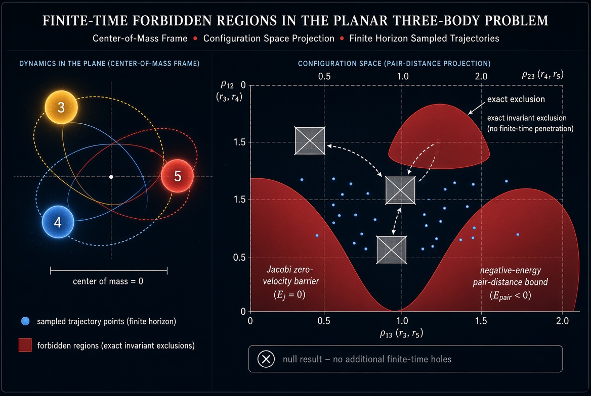
We recovered two exact invariant exclusions as analytic controls. In the Earth–Moon circular restricted three-body problem at fixed Jacobi constant, any point where the effective potential yields a negative squared speed is unreachable by a real velocity. On the unrestricted planar energy surface corresponding to the classical Burrau (3-4-5 Pythagorean) problem with zero angular momentum, at least one pair of bodies must always satisfy a hard upper bound on separation of approximately 3.667. Both statements follow directly from the conserved quantities and require no trajectory sampling.
Does this solve the three-body problem? No. It does not provide a universal formula for predicting three gravitating bodies indefinitely. It investigates a narrower question: whether specified regions can be ruled out over a finite horizon without predicting the exact trajectory.
We then asked whether a broad fixed-invariant family in the unrestricted planar problem produces any additional finite-time exclusions over a horizon of three characteristic cycles. Positions and velocities were sampled on the invariant manifold (masses 3, 4 and 5; fixed Newtonian energy equal to the classical Burrau value; zero center-of-mass, total momentum and angular momentum; moment of inertia between 15 and 120; minimum initial separation 0.2). Adaptive classical RK4 propagated 450 000 attempted states; 323 466 complete trajectories passed a strict energy-drift gate. Physical-space and full three-pair-distance occupancy were recorded across more than 6.7 billion reported integration steps when the restricted-problem control campaigns are included.
Unvisited voxels whose centers passed elementary feasibility filters (triangle inequalities plus the kinetic-energy lower bound implied by angular momentum) were treated only as discovery candidates. They were ranked by interior depth after binary erosion, then attacked with differential evolution that stayed algebraically on the same invariant manifold. Every selected survivor—including the deepest expanded-domain targets—was reached by a high-accuracy, independently re-integrated numerical trajectory. High-order DOP853 re-integrations at successively tighter maximum steps confirmed entry into the inset interiors with pair-distance spreads orders of magnitude smaller than the safety margins.
No candidate survived adversarial falsification. Interval certification was therefore never initiated, and no new theorem is claimed. The primary outcome is a null result for additional numerical finite-time exclusions in the tested family and horizon.
That null is informative. Sparse occupancy maps can visually suggest forbidden structure that disappears under directed search. The asymmetric evidentiary rule used here—one verified hit destroys a candidate, while any number of optimizer misses fails to prove exclusion—prevents the common error of treating empty cells as proof. Exact Jacobi and negative-energy barriers remain valid. The campaign simply shows that, for this broad fixed-invariant ensemble and finite horizon, no further robust holes survived the discovery–falsification chain.
Conceptually the method reasons from negative space: remove what is certified impossible, and the remainder is an outer envelope of where the system may be. That remainder is possibility, not a probability distribution, and “not proved forbidden” is not the same as “proved reachable.” Finite-time forbidden-region statements are therefore a meaningful alternative to indefinite point prediction, provided the evidence is typed correctly—invariant proof, numerical candidate, adversarial survival, or validated certificate.
The full blinded manuscript (methods, claim taxonomy, all attack seeds, strict step-convergence data, limitations, code and data availability statements) is available on request. Reply or direct-message “PDF” and I will email a copy.
The correct publishable outcome is the null result itself.
Research-assistance disclosure: The mathematical synthesis, computational workflow, software development, numerical analysis, and manuscript drafting were performed with substantial assistance from Arena.ai Agent Mode under the author’s direction. The author executed and supervised the study and accepts responsibility for the published claims.
In today’s crazy world, researchers are often caught in a relentless pursuit of knowledge, sacrificing personal time to meet tight deadlines or answer one more query. This cycle can wear anyone down, leading to decreased productivity and overall well-being. As professionals dedicated to our field, it’s crucial to strike a balance between our professional ambitions and personal lives. The key? Setting boundaries that rejuvenate us while advancing our careers.
First off, let’s address the elephant in the room: Why bother setting boundaries when there’s so much work to be done? The answer is simple. Burnout is real, and it can crush creativity and productivity. By ensuring we have time to rest, recharge, and engage with life outside of research, we become better researchers. Our minds are sharper, our solutions more innovative, and our resilience against stress higher.
So, how do we actually implement these vital boundaries? Here are some practical strategies that can help shape a healthier work-life balance:
Define your limits: Know what you’re willing to commit to in terms of hours per day or week. It’s okay to say “no” to additional tasks if they’ll overrun your boundaries. This helps prevent the ‘just one more thing’ syndrome that leads to late nights and weekends spent at work.
Learn to delegate: If possible, share your workload with colleagues or train your team members to assist with certain tasks. Delegation not only lightens the load but also fosters a collaborative environment where everyone contributes equally.
Schedule breaks: Taking regular short breaks can significantly improve focus and efficiency. Use these times to stretch, take a walk, or simply rest your mind, which can lead to more meaningful work when you return.
Set specific work hours: Decide when you’ll work, stick to it, and create a mental barrier at those times. This trains your brain to focus intensely during your work hours and rest during off-hours, enhancing both your productivity and relaxation.
Digital detox: Limit your screen time after work to unwind and connect with the real world. Whether it’s an hour before bed or a full weekend without devices, this can significantly reduce stress levels and improve sleep quality.
Prioritize tasks: Not all work is created equal. Identify your most important tasks and focus on those first, ensuring you’re making progress on what truly matters rather than getting lost in less critical details.
Foster a support network: Surround yourself with friends, family, or a community who understand your commitments and can offer support when needed. Talking through challenges or celebrating small victories with others can provide a much-needed perspective shift.
Remember, maintaining work-life balance doesn’t mean you’re not dedicated to your job; it means you value your overall health and well-being enough to excel at what you do. By setting and respecting these boundaries, you’re not just taking care of yourself—you’re also enhancing your ability to contribute meaningfully to the world of research.
So let’s commit to bettering not only our careers but our lives by establishing healthy boundaries. Your future self will thank you for it.
Leading a team requires a multitude of skills, but one often overlooked yet supremely vital is effective time management. In the fast-paced world of business, where demands stack higher than ever and expectations soar, a leader who can’t manage their own time is like a captain who loses sight of the compass—wandering aimlessly and risking the ship’s safety. We all know that leading by example in the realm of time management can make all the difference.
First things first, let’s dive into why time management is essential for leaders. A leader’s calendar is often packed, filled with meetings, strategic planning, employee concerns, and an endless stream of emails. The ability to prioritize, focus on what’s urgent, and delegate effectively ensures that leaders not only keep their heads above water but also set the pace for their teams. If a leader is constantly behind or overwhelmed, it sends a ripple effect through the team, causing stress and impacting productivity.
To lead by example, here are some actionable tips:
Schedule Wisely: As a leader, you must learn to say ‘no’ to non-essential activities. Your calendar is a reflection of your values and priorities. Fill it with tasks that align with your objectives and the well-being of your team. This practice not only helps in setting boundaries but also sends a powerful message to your team about respecting one’s own time.
Set Clear Expectations: Clarity is key. Clearly define what’s expected from each team member, including yourself. Set realistic goals and deadlines that are challenging yet achievable. When your team knows what’s required, they’ll be more likely to manage their time effectively, mirroring the discipline you’ve demonstrated.
Delegate Like Your Time is Valuable: As a leader, your role is to strategize and guide. Delegating tasks allows you to focus on high-priority activities that require your direct attention. It’s also an excellent leadership skill that empowers your team members, giving them the confidence and opportunity to grow.
Prioritize the Important Over the Urgent: Urgency often takes precedence, but it’s not always where we should be focusing our efforts. By learning to distinguish between what is truly important and what is simply urgent, you’ll find yourself making smarter use of your time and achieving more meaningful results.
Take Care of Your Well-being: A leader who neglects their own well-being won’t be effective for long. Make sure to carve out time for rest, exercise, and hobbies that recharge your batteries. When you take care of yourself, you’re better equipped to take care of others, including your team.
Leading by example in time management means you must first master the art of managing your own time effectively. This can be achieved by adopting a disciplined approach, setting a positive example for your team, and continuously striving to improve. Remember, a leader’s time is often the most valuable resource they have. By managing it wisely, you not only enhance your own productivity but also cultivate a culture of time-consciousness within your organization, leading to greater success and fulfillment for everyone involved.
Used to distinguish new sessions and visits. This cookie is set when the GA.js javascript library is loaded and there is no existing __utmb cookie. The cookie is updated every time data is sent to the Google Analytics server.
30 minutes after last activity
__utmc
Used only with old Urchin versions of Google Analytics and not with GA.js. Was used to distinguish between new sessions and visits at the end of a session.
End of session (browser)
__utmz
Contains information about the traffic source or campaign that directed user to the website. The cookie is set when the GA.js javascript is loaded and updated when data is sent to the Google Anaytics server
6 months after last activity
__utmv
Contains custom information set by the web developer via the _setCustomVar method in Google Analytics. This cookie is updated every time new data is sent to the Google Analytics server.
2 years after last activity
__utmx
Used to determine whether a user is included in an A / B or Multivariate test.
18 months
_ga
ID used to identify users
2 years
_gali
Used by Google Analytics to determine which links on a page are being clicked
30 seconds
_ga_
ID used to identify users
2 years
_gid
ID used to identify users for 24 hours after last activity
24 hours
_gat
Used to monitor number of Google Analytics server requests when using Google Tag Manager
1 minute
_gac_
Contains information related to marketing campaigns of the user. These are shared with Google AdWords / Google Ads when the Google Ads and Google Analytics accounts are linked together.
90 days
__utma
ID used to identify users and sessions
2 years after last activity
__utmt
Used to monitor number of Google Analytics server requests
10 minutes
You can find more information in our Cookie Policy and .